Dr Köpken-Watts, a weather forecast is based on many different sources of data. Which sources does the German Weather Service (DWD) use and what role do meteorological satellites play?
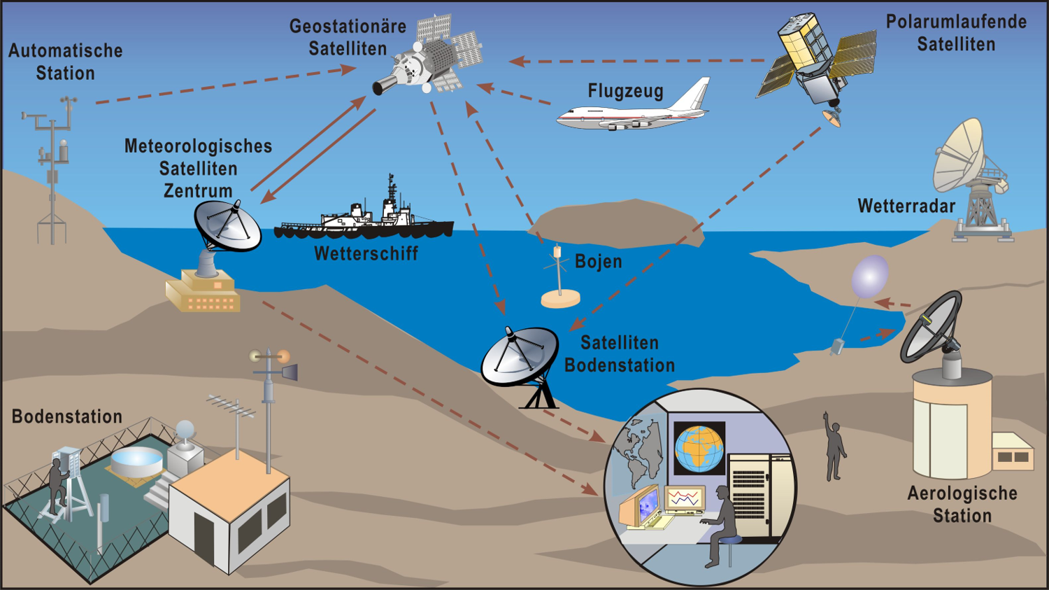
Numerical weather prediction always starts from an analysis of the state of the atmosphere, which incorporates many different measurements. These include various direct observations, known as conventional data, such as aerial measurements acquired by aircraft and radiosondes – also known as weather balloons – as well as surface measurements from ground stations, ships and buoys. In addition, remote sensing data from ground-based systems such as radar stations and wind profilers and a wealth of data acquired by different satellites and instruments are used. The satellite data are essential for operational numerical weather prediction and play a major role in its continuous improvement. More than 85 percent of the data used for global modelling at DWD now come from satellites. The quantity of these data and their importance to forecasting will continue to grow, particularly with the advent of new generations of satellites.
Also for short-range forecasting, which covers a period of up to the next 12 hours, satellites play an essential role, together with conventional data and data from the nationwide radar station network.
The satellite data we use come from both geostationary and polar orbiting platforms managed by satellite operators in various countries. EUMETSAT in Darmstadt plays a very important role for us as it develops and operates satellite systems that are essential for weather forecasting and also distributes data acquired by other international satellites to European weather services.
What benefits do meteorological satellites offer to you as a weather service?
Meteorological satellites offer excellent coverage of the entire planet over land, water and ice. Depending on the instrument and orbit, they can also provide high temporal resolution. By using different measurement techniques and technology, they provide diverse measurements of many essential parameters such as air temperature, humidity, wind, surface temperature, vegetation, snow and ice cover and even concentrations of trace gases and aerosols. The use of these data significantly benefits many areas of our work and enables us to create a wide range of customer products.
Many of these products are based on numerical weather prediction and satellite data are essential for producing the high-quality analyses that serve as the starting point for these forecasts. We and other weather services regularly measure their impact in several different ways. One method involves computing forecasts for various test scenarios in which a portion of the satellite data or all satellite data are excluded. We then examine the quality of the resulting forecasts for such test periods. One such study found that satellite data reduced the errors in one-day forecasts provided by the European Centre for Medium-Range Weather Forecasts (ECMWF) by more than 60 percent. To cite another example, when satellite data are excluded, many extreme events such as storms in Germany or tropical cyclones cannot be well predicted or are only predicted much closer to the event. The forecast improvements achieved using satellite data have thus direct benefits for all end users and in many cases, they facilitate earlier warnings.
In addition to data assimilation, satellite data are used to evaluate and improve the physics-based numerical models. In particular, temporally and spatially high-resolution satellite data in different spectral channels allow to analyse clouds and radiative processes which are difficult to capture with conventional data. Improving the precision with which we can map physical processes in our models leads to more accurate predictions.
Finally, satellite data is increasingly important for monitoring the climate and how it is changing. Satellite data now stretch back over approximately 40 years, constituting time series for many key parameters such as cloud properties, solar radiation, atmospheric moisture content, ocean temperature and ice cover.
Weather forecasting has become increasingly accurate in recent decades, thanks in part to satellite data. What exactly is the reason for this?
The weather forecast system is continuously being improved and several times a year, updates are introduced to the data assimilation – the use of observational data – and to the current numerical model. These advances are supported by parallel improvements to the available computing resources, which are harnessed through the use of new hardware and the adaptation of weather forecasting software programs. These changes allow us to integrate an ever-increasing volume of satellite data which contribute to the overall increase in forecasting accuracy.

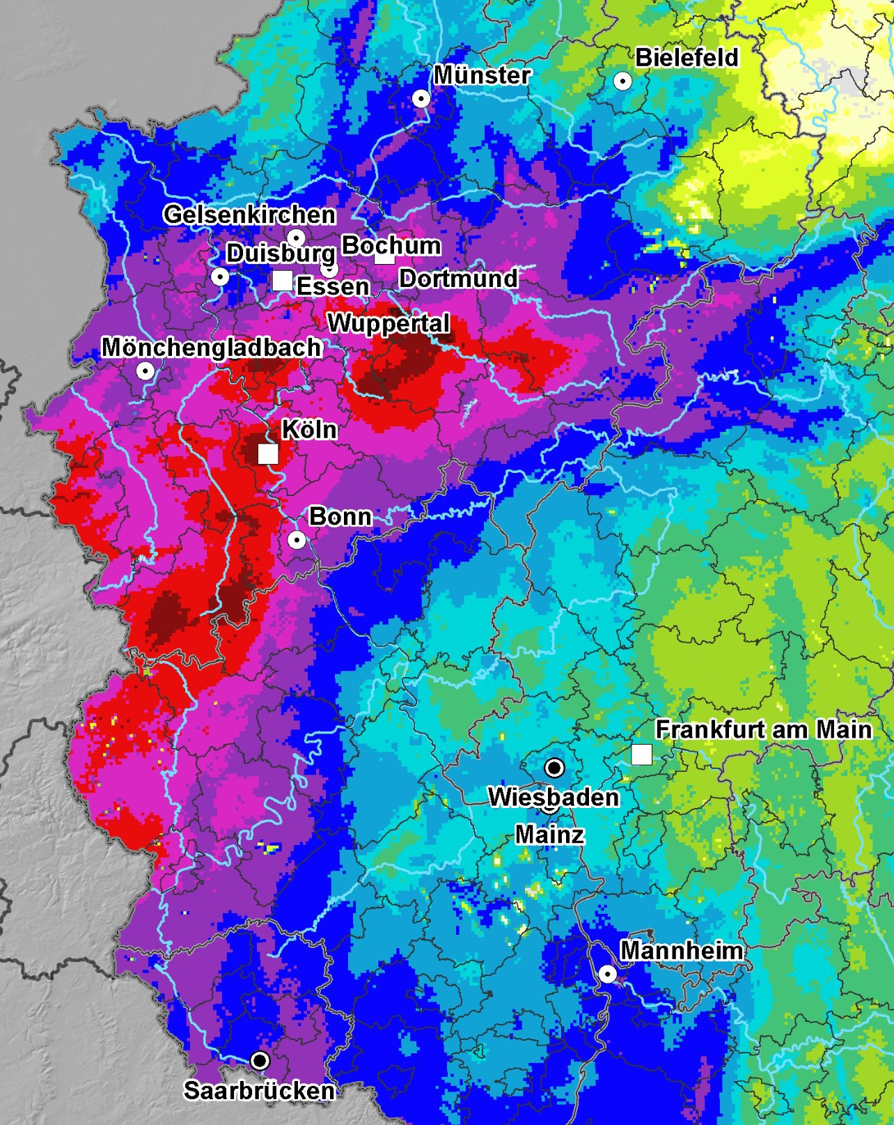
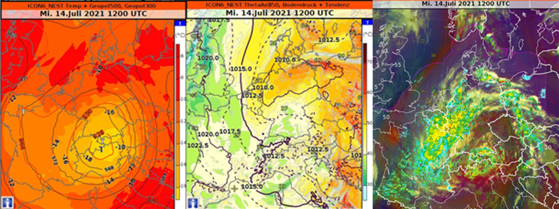
In mid-July 2021, the west of Germany was hit by extreme storms. Rhineland-Palatinate and North Rhine-Westphalia were the worst affected. In parts of the two federal states, 100 to 150 litres of rain per square metre fell within just 24 hours on 14 July and during the night of 15 July. On average, less precipitation fell in the entire month of July. The heavy rain triggered flash floods and massive flooding in the affected regions. As precipitation continued, medium-sized and larger rivers such as the Ahr, Emscher, Erft, Kyll, Lippe, Prüm, Ruhr, Rur, Sieg and Wupper also overflowed their banks. This resulted in widespread flooding from the Eifel (Rhineland-Palatinate) through the Rhineland and the Ruhr region to southern Westphalia (North Rhine-Westphalia). The heavy rainfall events led to at least 180 deaths and damages amounting to around 33 billion euros in Germany. The storm triggered by the low-pressure weather system Bernd also caused damage, some of it considerable, in parts of Belgium, France, the Netherlands, Luxembourg and other regions of Europe. The images show the precipitation levels within 72 hours (left) and a satellite image of the heavy rain area. (© DWD)
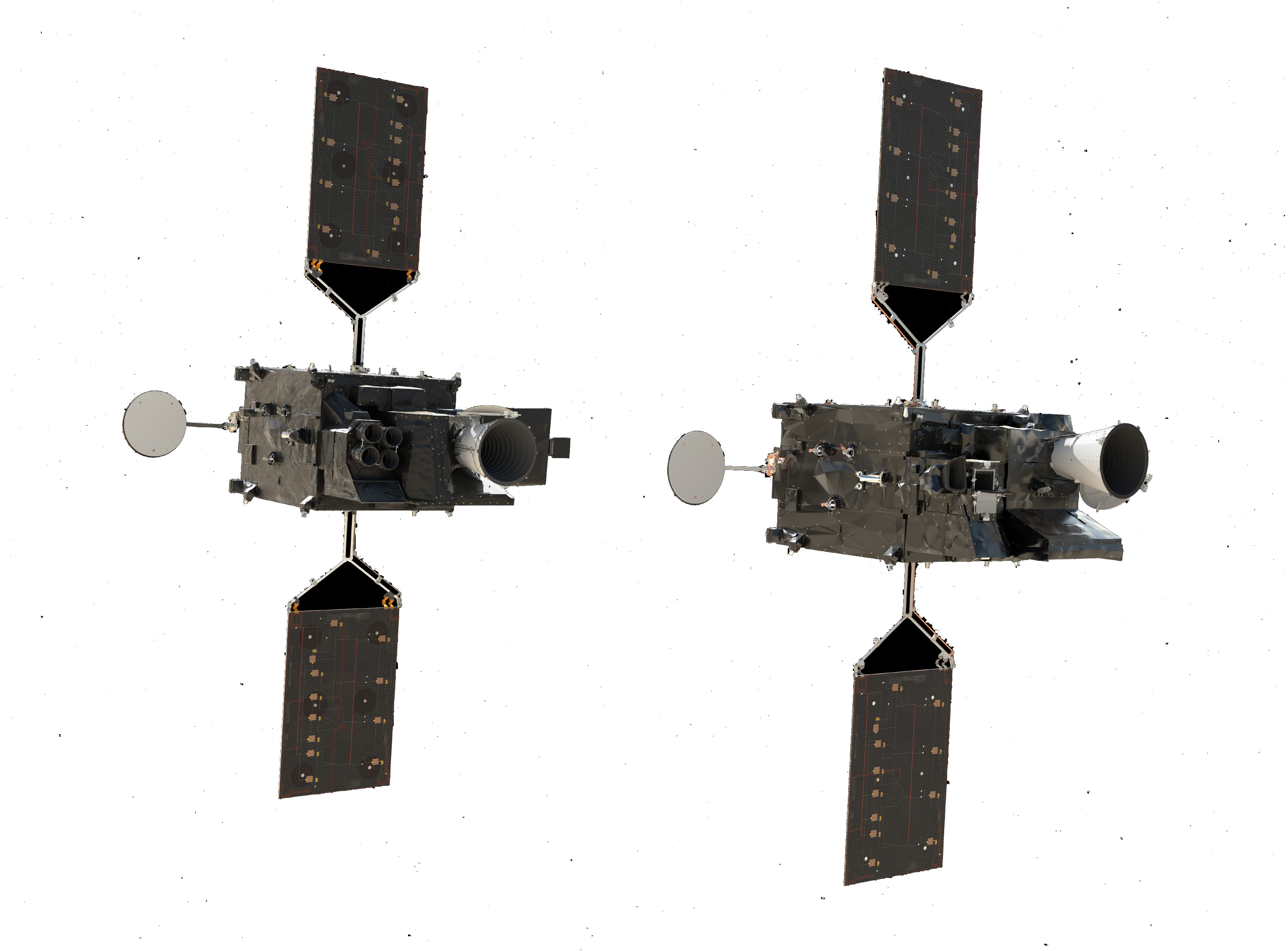
The Meteosat Third Generation (MTG) is set to significantly improve the accuracy of weather forecasting once again. How important is MTG from the point of view of the weather service and what improvements do you hope to see enabled by this new series of satellites?
Data from the current Meteosat Second Generation (MSG) geostationary satellites are routinely used in global numerical forecasting to improve the analysis of atmospheric humidity fields and to derive wind vectors from cloud displacement. The improved temporal and spatial resolution provided by the Flexible Combined Imager (FCI) instrument on the new Meteosat Third Generation (MTG)-Imager satellites will increase the accuracy of these observations. FCI will also provide valuable data for the high-resolution very short-range forecasting, where DWD will soon introduce operational use of observations in the visible spectral range. This further improves especially cloud forecasting and predictions of near-surface temperature and solar radiation benefiting, for example, the management of energy production from renewable sources.
In addition to the FCI, the MTG-I satellites are also equipped with the new European Lightning Imager (LI), which we expect to be useful in validating and improving models with respect to their ability to simulate and forecast thunderstorms. The goal of this research is to use these data directly in the analysis used to generate forecasts.
However, the new data also offer interesting potential for other DWD applications, such as those in the field of ‘nowcasting’, covering the next one to six hours. Both the FCI and the LI are expected to bring improvements in this area. The higher data resolution, for example, will facilitate the generation of short-range forecasts for private customers and the energy sector that provide more spatially accurate predictions of solar radiation. Similarly, we hope that these instruments will help us to better detect small-scale fog formation. The higher resolution and new spectral channels of the FCI will also help detect volcanic ash and ice clouds, both of which are important for the aviation industry.
Another area with expected benefits is early warnings of thunderstorms. The improved capabilities of the FCI and the LI will allow us to improve our understanding and make more precise statements about which convective clouds develop into thunderstorms. The horizontal coverage of the satellite will extend and complement the radar network range. In addition, the LI will allow us to identify cloud-to-cloud lightning complementing the predominantly cloud-to-ground lightning measurements from existing ground sensing networks. All these aspects are expected to improve the early detection of thunderstorms as well as the estimation of their lifetimes, which will in turn improve DWD's thunderstorm nowcasting and live thunderstorm forecasts, e.g. for pilots.
Finally, the FCI on the MTG-I satellites will also be used for climate monitoring. The satellites will continue the time series of geostationary observations that began more than 40 years ago and will be used to monitor cloud properties and solar radiation in particular complementing the ground-based German network.
What kind of improvements can we expect in the more distant future?
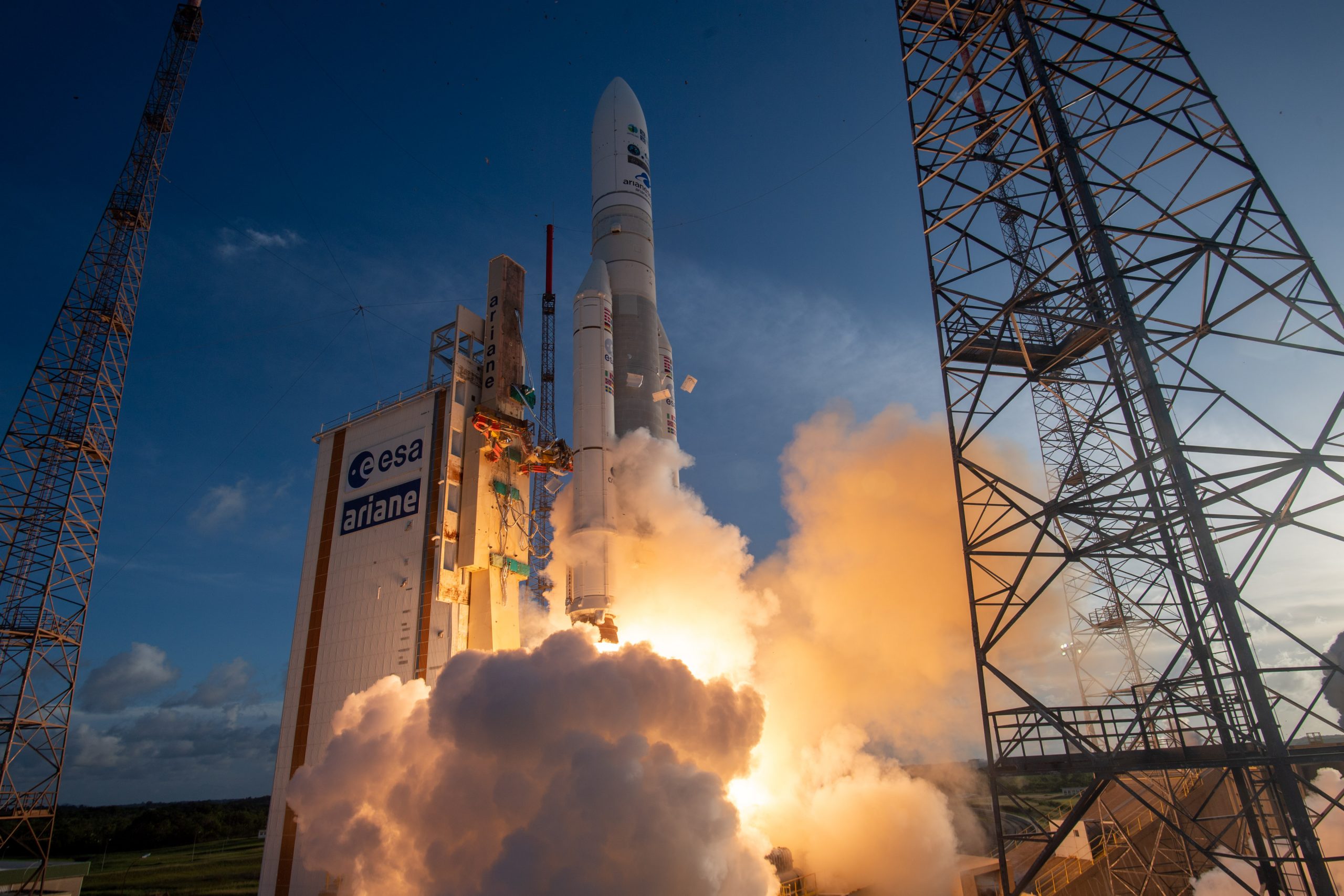
The launch of the first satellite in the MTG programme, MTG-I1, will give new impetus to efforts to improve the processes that use its data and will help generate the investments required to turn these processes into applications. This is where both weather services and research partners come in. Over recent years we already prepared and extended our algorithms using simulated data in parallel to the development of the new instruments. Our experts are therefore in the starting blocks and ready to quickly incorporate the new data into their procedures.
Even so, there will be a learning curve associated with the new data: improvements and innovations will develop over the course of the satellites’ lifetime. The volume of data generated and the parallel availability of data from both FCI and LI, as well as advanced approaches using machine learning and other technologies, can all be expected to advance exciting innovations in weather forecasting.
As we look to the future – beyond the recent launch of MTG-I1 – we should also mention the second component of the MTG programme, the MTG-Sounder satellites, the first of which is expected to be launched in 2024. These will carry two new instruments, the hyperspectral Infrared Sounder (IRS) and the Ultraviolet Visible Near-infrared spectrometer (UVN), which will also serve as Sentinel-4 in the European Union’s Copernicus Earth observation programme. With these instruments, Europe will take measurements with high spectral and spatial resolution and especially much higher temporal resolution than is currently available from comparable instruments on polar-orbiting satellites. These observations will allow us to generate temperature and humidity profiles and map out the concentrations of trace gases and aerosols with continuous coverage and in high resolution.
Severe weather warnings have become a part of our everyday lives, but it is still difficult to accurately forecast thunderstorms. How exactly can MTG data help to optimise these warnings?
Short-term thunderstorm warnings are based on operational nowcasting processes, which currently typically only consider ‘advection’ and thus extrapolate the observed displacement into the future. The new Meteosat Third Generation (MTG) data could provide the information needed to improve nowcasting; for example, its higher temporal and spatial resolution may enable us to detect emerging convection earlier than we currently can. The flexible combined imager (FCI) also makes it much easier to detect phenomena such as ‘overshooting cloud tops’, which are indicative of severe convection and therefore potentially severe weather. As already mentioned, the LI adds in lightning information. Novel techniques are now combining nowcasting with short-range numerical weather prediction to better capture physical aspects such as the formation or decay of storm cells. As nowcasting techniques and numerical prediction will both benefit from the new MTG observations, we can expect that the new satellites will lead to advances in thunderstorm forecasting.
In your experience, what is the role of data in climate change?
Activities related to climate change require a reliable and continuous set of observations – that is, a long time series of consistent data that is very well calibrated and documented. The FCI instrument on MTG will continue the time series of geostationary Meteosat observations that stretches back more than 40 years. The continuity of this time series and its evaluation is ensured by the long initial calibration and evaluation phase that each new satellite instrument goes through after launch and comparisons between data acquired with the new instruments and measurements from reference instruments. Using the data, we can also extend the time series of derived parameters such as solar radiation, cloud cover and additional cloud properties. MTG also allows us to climatologically assess new information related to cloud properties in conjunction with the current MSG satellite data.
If you had one wish, what data would you like to receive from satellites in the future that you do not currently have at your disposal?
For now, in the period following the launch of MTG-I1, we should focus on exploiting this new data source. There is a great deal of work to be done at EUMETSAT during the commissioning phase to make this data operationally available to users and on the user’s side to integrate this data into their procedures in the best possible way. We will certainly go through a steep learning curve particularly as they will soon be combined with important data from the IRS and UVN instruments on the first MTG-Sounder satellite. This will then be joined by EUMETSAT Polar System Second Generation (EPS-SG) satellites from 2025 onwards, also providing additional new, exciting and highly complementary instruments and data. As we gain experience with these new data sources, the scope for further improvements in the future will become clear, and I will be better able to answer your question.
So, for now, I would say: “Let’s roll up our sleeves and get to work with MTG!”